We were celebrating an anniversary this weekend, and ventured off to the Smokey's for a long weekend by ourselves, leaving the rest of our gang behind. We rented a cabin in Pigeon Forge with the requisite steep driveway, and used it as home base for our hiking expeditions. Our hikes the first day had us driving from the northern end of Newfound Gap Road to the southern end. I was hoping to catch a glimpse of the snow that had fallen up at Clingman's Dome area on May 5/6, 2016, and while we did catch a glimpse of what was left as we drove through, by the time we came back later the same day, what we had see earlier was melted.
We had looked at the forecast earlier in the week, and the hubster said that it was suppose to be in the 80's and sunny on Saturday and Sunday. Once we got to the cabin, we didn't have any cell service (and the internet was non-functioning), so we didn't check the forecast again. Based on the previous forecast, we both left our rain gear in the cabin. At Newfound Gap, we stopped to catch the views and were blasted with 48 degree Fahrenheit wind. We did have a coat each, so that was not an issue, but as we headed down toward Oconaluftee, it started a steady drizzle. So chalk this up to a rookie mistake/lesson learned. I will never again leave my rain gear behind, despite what the hubster or the forecast says. It will be strapped to my pack. We drove into the parking lot of the Oconaluftee visitor center and greeted with overcast skies, but the drizzle had stopped.

Views from Newfound Gap, looking out over North Carolina. The photos do not do it justice. The mountains just went on and on, very beautiful.

We reached the trail head just outside the Oconaluftee Visitor's Center and while the drizzle had stopped, but it was only in the low 50's.
The Oconaluftee River Trail is a 1.5 mile in-and-out trail, so it added 3 miles to our 100 Mile Centennial Challenge, and 1.5 miles to the 900 Miler Challenge. It was a slow, meandering hike with little elevation change and is one of two hikes in the park that allow dogs on the trail. We did the other hike, coincidentally, the following day (more on that later). The Oconaluftee River Trail ends in the town of Cherokee, NC, a Cherokee Indian Reservation.

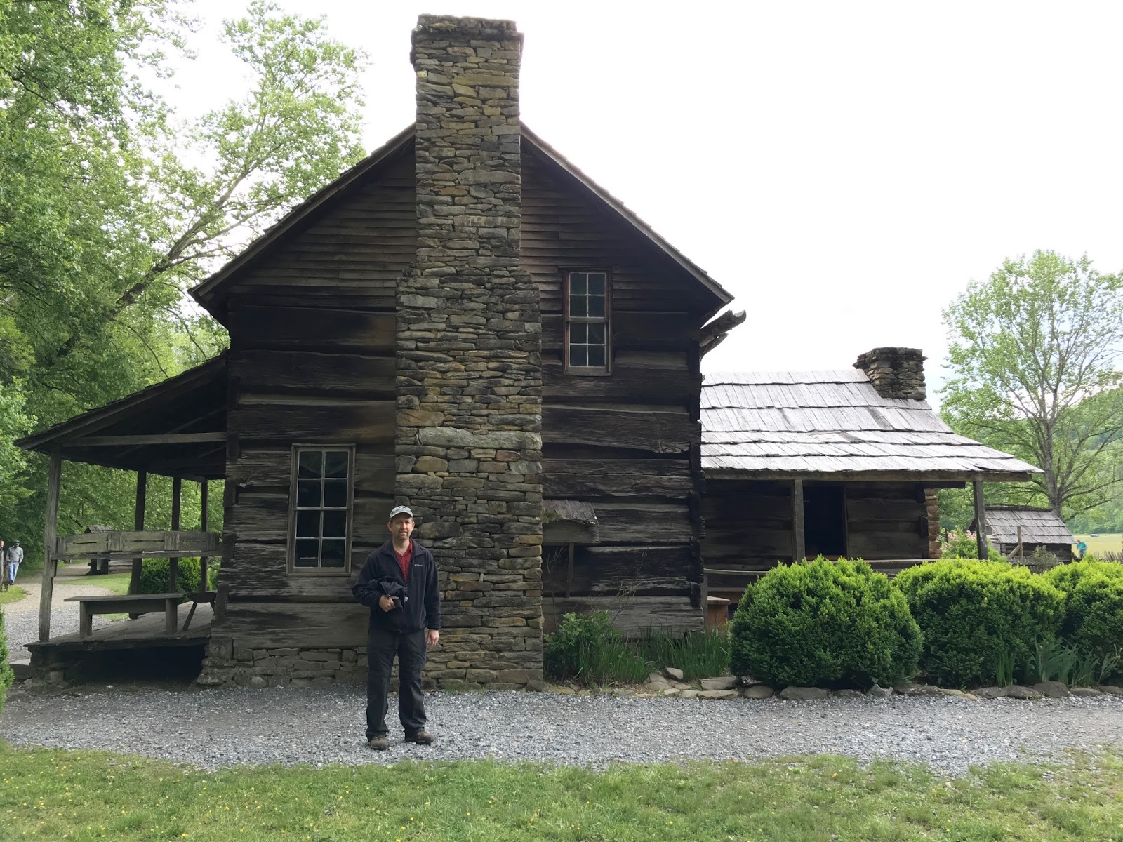
Right outside the visitor's center is a "mountain farm museum" with several styles of log cabins, barns, out buildings (outhouse included) and fields/gardens. It is very well maintained and made for a peaceful setting to take pictures. There weren't a lot of visitors, and the trail meandered by the "museum" and on into the woods.

Parts of The Great Smokey Mountain National Park are classified as a temperate rainforest, and although I don't know what parts for sure fall within that classification, I can easily talk myself into believing that the Oconaluftee River Trail is part of the temperate rainforest. It was such a lush, damp, green, flowery walk. Vegetation everywhere ... Flowers everywhere. Flowers are very distracting and I personally don't find that to be a problem, but if we are to make any headway on a hike ... let's just say flowers slow us wayyyyy down.

The hubster by a big tree ...


The trail went under the Blue Ridge Parkway. The trail followed the Oconaluftee River (hence the name, one would imagine ...) and since it is on/near the Cherokee Indian Reservation, I had to take a photo of the sign. I saw other signs saying that fishermen in the river could only catch and release, which I assume (one should never do that, BTW), does not apply to the Cherokee themselves, which is as it should be.


Sweet Shrub blossoms

Dog Hobble

I think this is Dog Hobble too, but I may be wrong on this one. (wouldn't be a first)


More Dog Hobble


Park Boundary. Cherokee, NC just down the road.


Beginning of Mountain Laurel blossoms. I can't wait to come across a whole trails-worth of these.


Lisa, I'll be you know what this one is?! I can't figure it out, if you know, pass your knowledge along, I don't think I've ever see it before.
Update: After requesting assistance with identifying this flower at "Hike The Smokies" FB page, I am told this is "Hearts-A-Bustin'," (Euonymus americanus). Thanks to Betsy Lee.

Squaw Root, in it's elderly stage.

Oconaluftee River

This was warning those heading up to Newfound Gap. Yes, ice/snow even in May.


Another giant tree begging to be photographed.


We ended the hike in no record time, thanks to my flower-hunting. I was looking for Jack all weekend and never did see him (Jack-in-the-Pulpit). So I took excessively long to go the total of 3 miles, dear hubster is endlessly patient with my pauses.
I'm in a quandary about whether or not to continue posting our mileage as it does not reflect the entire group at this point. I talked to Pam briefly, and she said to post it, so I will for now. But I think we may have to start keeping our own personal records as it is becoming complicated. My mileage is different than the hubster's even. The following is our stats, although we are going to have to develop a different strategy for keeping track of our mileage.
Trip Stats:
Mileage for In and Out Hike - 3.0 miles
Miles Added to the 900 Mile Challenge - 1.5 miles
Total Miles Hiked toward the 900 Mile Challenge: 46.2
Mileage added to the 100 Year Centennial Hike Goal - 3.0
Total Miles Hiked for the 100 Mile Centennial Goal - 40.4
I don't know what it is. I couldn't find it in my books. Post it on Hike the Smokies.
ReplyDeleteThis comment has been removed by the author.
ReplyDeleteI feel a bit better then Lisa! I scoured my books and didn't see anything resembling it. Will have to post it there. Thanks for looking. Your are, by the way, our first comment
ReplyDelete